Transportation Infrastructure
Speakers

Rolta
India

Trimble Planning Solutions
Australia

Market Intelligence and Business Consulting Geospatial Media and Communications
India

Department of Atomic Energy
Tata Institute of Fundamental Research

Geokno & Professor IIT Kanpur
India

AAM
India

Telecom Development, Railway Board
India

Bentley
India

IIT Roorkee
India
, RailTel Corporation of India Ltd, (Ministry of Railways)")
RailTel Corporation of India Ltd
(Ministry of Railways)

.png "Bill Collins, Executive Vice President, GRMC,")
GRMC
IIC Technologies

MacDonald Dettwiler and Associates
Canada

Genesys International
India

Leica Geosystems

Gayatri Projects Ltd.

Ministry of Infrastructure and the Environment
The Netherlands

Hi-Target Surveying Instrument
China

SATRA Group

IT Unit of Planning and Road Asset Management Centre
Karnataka Public Works, Ports & Inland Water Transport Department
India

Terrasolid
Finland

Hitachi
India

ADCC Infocad Ltd
Programe Agenda
Day 1: 24th January, 2017
Keynote Session: Leveraging Geospatial technologies for development of sustainable transportation infrastructure
Networking Tea/Coffee Break and Visit to Exhibition
Networking Lunch
Developing a Geospatial framework for modernization in Railways sector
Networking Tea/Coffee Break
Towards Digital Railways
Day 2: 25th January, 2017
G - tech for planning and building road and highway transportation infrastructure – survey, design, and planning
Networking Tea/Coffee Break and Visit to Exhibition
Networking Lunch
G - tech for planning and building road and highway transportation infrastructure – construction, maintenance and evaluation
Towards Sustainable Transport Infrastructure with G-Tech
Transportation is vital to the well-functioning of economic activities and a key to ensuring social well-being and cohesion of populations of any country. One cannot overemphasize the importance of transportation than call it the 'lifeline' of a nation. Adequate and sustainable infrastructure is a fundamental precondition for transport systems and it has been proven by so many instances how transport infrastructure has added speed and efficiency to a country's progress.
However, in their endeavour to facilitate transport and develop a sustainable transport infrastructure, decision-makers in governments and international organizations face difficult challenges. These include the existence of physical barriers or hindrances, such as insufficient or inadequate transport infrastructures, bottlenecks and missing links, as well as lack of funds to remove them. Solving these problems is not an easy task. It requires action on the part of the governments concerned, actions that are coordinated with other governments at international level.
This decision making needs inputs in the form of relevant data. Large data systems are capturing significant performance, operational and planning data in the transportation industry. These data can not only assist in decision making but also improves service evaluation, customer satisfaction, operational efficiency and overall system performance, leading to a sustainable transport infrastructure. At the core of most of this data are spatial elements that describe the location of relevant transport data like transit boarding, customer location, activity centres, assets and transit service.
Geospatial technology provides a unique advantage of gathering, organizing, evaluating and communicating data; transforming data into information. GIS is a powerful, efficient tool to construct and analyze transportation networks; conduct impact assessments; and create visual representations of assets, project locations, and transportation data layers.
Understanding the value of geospatial technologies in managing transport infrastructure, enhanced decision making, enhancing the efficiency of workflows, and improving the accessibility of information, an exclusive two day symposium for transport infrastructure is being organized with the theme: "Towards Sustainable Transport Infrastructure with G-Tech" on 24th and 25th January as part of the Geospatial World Forum – 2017.
Symposium Overview
This symposium will bring experts from around the world on how Geospatial technology is being used every day to develop sustainable transport infrastructure & improve transport systems. It will also discuss the prospects and applicability of the Geospatial technology in various phases of developing transport infrastructure. The symposium will provide a breadth of Geospatial experiences to showcase how agencies of all sizes and budgets are utilising this technology and improving transportation service and ultimately developing a sustainable transportation infrastructure. The aim of the symposium is to advocate extensive use of geospatial technologies for sustainable transport infrastructure development.
Geospatial in the Life Cycle of Transport Infrastructure
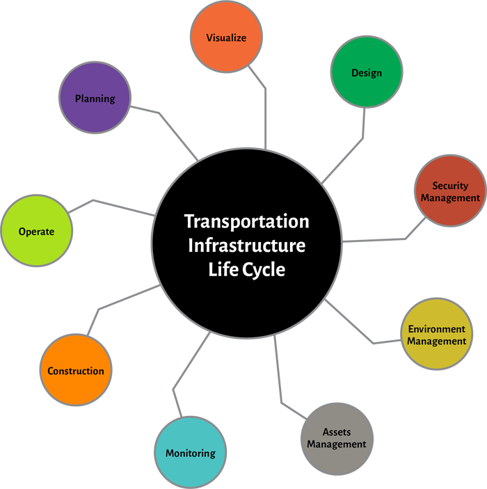
Throughout the transport infrastructure life cycle, Geospatial Technologies help us to create a seamless flow of information from one stage to another. These technologies can be integrated in the whole process starting from visualization of the assets, to design, planning and then carried over into other areas such as built drawings, operations and maintenance. In this symposium we will try to understand the role of geospatial and other technologies majorly on three main areas as shown below:
Day 1: 24th January, 2017
Keynote Session :Leveraging Geospatial technologies for development of sustainable transportation infrastructure
Geospatial technology has immense potential to be a decision support system across various stages and aspects of transportation infrastructure – from planning, building, maintenance, load management, navigation, automation, passenger information management, safety, vehicle tracking, and environmental concerns. This session will witness deliberations from policymakers and decision makers of the transportation industry across the globe regarding their vision on the numerous geospatial solutions and innovations for a sustainable transportation infrastructure development and management.
Session 1: Developing a Geospatial framework for modernization in Railways sector
Rail System is one of the major transport systems in the world. It includes railway line design, build, construction, monitoring, management and maintenance. The need is of a platform for analyzing rapid advancements, tools and technologies like remote sensing, GIS, GNSS/GPS and automated machine controls.
This session will deliberate on these key strategies for modernization in Railways sector. The major focus of the session would be to understand the role and relevance of geospatial technologies in survey, planning, designing and constructing the new routes and also in monitoring and managing the existing routes. The eminent speakers like surveyors, planners, designers, constructors will bring forward the framework to maximize the uptake of the technology in the railway infrastructure project life cycle.
The themes for the session would focus on the application of Geospatial technologies in the four major phases of the railway project – survey and mapping, plan and design, construction, operations, maintence and safety.
Session 2: Towards Digital Railways
Digital Railway is the representation of the railway system that is spatially referenced and interconnected with the world's digital network. It incorporates the use of vast amount of geo-referenced information to present rail network in three-dimensional description of multi-resolution, multi-scale, multi-dimensional.
The session will focus on developing new railway information systems, digitization of the railway infrastructure (lines, bridges and tunnels, stations, signal system, etc.) and railway environment (dynamic and static information, multi-resolution and 3D information) based on geographical information system (GIS), Global position system (GPS), Remote system (RS), information system.
Day 2: 25th January, 2017
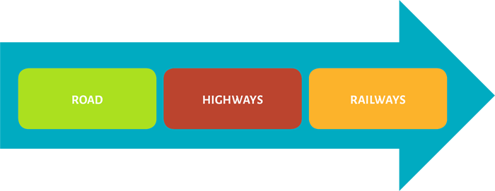
Session 1 & 2 : G - Tech for building Road and Highway Transportation Infrastructure
Roads are main arteries of modern society's infrastructure, contributing heavily to the distribution of goods and persons. Road agencies face an enormous challenge in keeping their infrastructure operating smoothly and efficiently. The Geospatial technologies play a major role in surveying, planning, designing, navigation, routing, traffic control and evaluation of the road network. GIS technology is combined with 3D and wireless communication technologies, GPS, to manage highway maintenance data.
This session will present the overall context within which various activities are carried out and will try to build an understanding of transport infrastructure projects particularly in roadways and highways. It will bring forth the major role of geospatial technologies in management of these activities, major challenges and the possible solutions.
The stakeholders of the community would focus on the application of Geospatial technologies at every level in the road and highways transportation project– surveying, mapping, planning, designing, construction, navigation, routing, traffic control, evaluation and maintenance.
Reasons to attend
- Discover the most recent advances in Geospatial Technologies enabling sustainable transportation infrastructure
- Ascertain the state of knowledge of G-Tech use in transport systems planning and management.
- Find out about the latest developments in models, programs, tools and techniques.
- Inform yourself about the use of G-Tech in sustainable transport infrastructure development across the globe and exchange information and experience on this.
Target Audience
- Road, Railways and Highways planners
- Road, Railways and Highways designers
- Road, Railways and Highways Engineers
- Research organizations & Academia
- Policy makers
- Construction Companies
- Infrastructure Companies
- Scientists
- Data Providers
- Consultants
For more information, please contact:
Ms. Jyotsana Chuchra
Senior Manager – Market Intelligence and Business Consultancy
Geospatial Media and Communications, India
T: +91 7838939560
E: jyotsana@geospatialmedia.net