Training Program on Fundamentals of Geospatial
11-12 May, EXHIBITION AREA - THEATRE 3
Explore the world of fundamentals of geospatial – photogrammetry, GIS, Remote Sensing, spatial analysis, and cartography. At the training session you will learn the basics on:
- Exploring the capabilities of geospatial for analysing spatial data and creating spatial outputs,
- Gain greater insights into data structures and their appropriate application.
- Learn the Basic Principles of Geospatial Technology
Lessons
Date: 11 May 2022
Fundamentals of Photogrammetry, Remote Sensing and Digital Twin
Time: 1000-1130 hrs & 1300-1430 hrs


The recent developments in photogrammetry and optical remote sensing allows for the generation of digital twins of all kind. Whether we want to provide a digital twin of a city, a landscape, a building or a technical device – everything is possible today. These options have been made possible by the inclusion of other technologies such as computer vision, computer graphics, serious gaming, and advances in machine learning and deep learning. Sustainable storage and further processing is guaranteed by cloud services, which are now also driving the metaverse. In addition, the digital twins can be provided in the form of MR (AR, VR) on any mobile device. For these reasons, we are highly motivated to offer an update to all those who want to deep-dive into one or the other technology. The training program is a multi-media course enriched by video clips and app demonstrations and is made available to all attendees, free of charge.
Topics to be covered
- Motivation for Digital Twins – Metaverse, sensor & data fusion, serious gaming, standards
- Photogrammetric data collection by passive and active sensor systems
- Photogrammetric data processing
- Optical remote sensing using high resolution satellite imagery
- Digital twin generation using interactive computer graphics and semi-automatic point cloud processing
- Machine Learning for automatic classification and processing of point clouds
- Deep Learning and point cloud classifications
 Trainer
Prof. Dr. Dieter Fritsch
Best Practices for High-Precision UAV Mapping using Lidar/Camera Payloads
Time: 1530-1700 hrs
Professional grade Lidar systems are currently being used onboard unmanned airborne systems for high precision mapping applications. This training is intended for the UAV LiDAR user community including mapping professionals, land surveyors, managers, and business decision makers to understand the underlying concepts of high precision mapping by Lidar from the technical and business perspectives, in the form of theory and practice, using real data sets from around the world.
Topics to be covered
- The Basic Concepts of LiDAR, Photogrammetry, GNSS, and Inertial navigation
- Project requirement identification
- Platform and payload choice
- Technology: Lidar and/or camera; RTK, PPK or DG
- Mission planning and site preparation
- Data acquisition and pre-processing quality control
- Data processing best practices
- Implications of a UAS payload calibration and quality control
- Accuracy assessment of UAS LiDAR mapping products
 Trainer
Dr. Mohamed M.R. Mostafa
Date: 12 May 2022
Geospatial Standards
Time: 1000-1130 hrs
It's certainly exciting to see geospatial at the center of several futuristic visions, such as digital twins, open Metaverse, or self-driving vehicles, just as it's humbling to see geospatial at the heart of responses to global issues like pandemics and Climate Change. The commonality across all of these visions and problems always comes down to data integration at scale! Standards make that possible: Standards make it possible to get from data to decision-ready information at scale to address problems that transcend disciplines, organizations, agencies, and jurisdictions. For more than 25 years, the Open Geospatial Consortium (OGC) has been applying its geospatial expertise for collective problem solving and making location information FAIR - Findable Accessible Interoperable and Reusable.
This session covers the landscape of OGC standards and best practices - with an emphasis on the new and emerging ones as part of the evolution and explosion of geospatial. Join us to learn about the future of geospatial standards: the OGC APIs - the building blocks of Location, 3D standards - the foundation for digital twins and the Metaverse, cloud best practices - the basis for scalability, EO standards and best practices - the launch pad of New Space, and more! Join us to discover how we are developing standards at the pace of innovation and how we are supporting our community's collective problem solving needs.
Topics to be covered
- Evolution of data and technologies
- The future in data integration
- The OGC APIs - building blocks for Location
- New Space standards and best practices
- Digital twin standards (3D, GeoPose, AR/VR and more)
- Bringing it all together for Open Science and Climate Change
 Trainer
Dr. Ingo Simonis
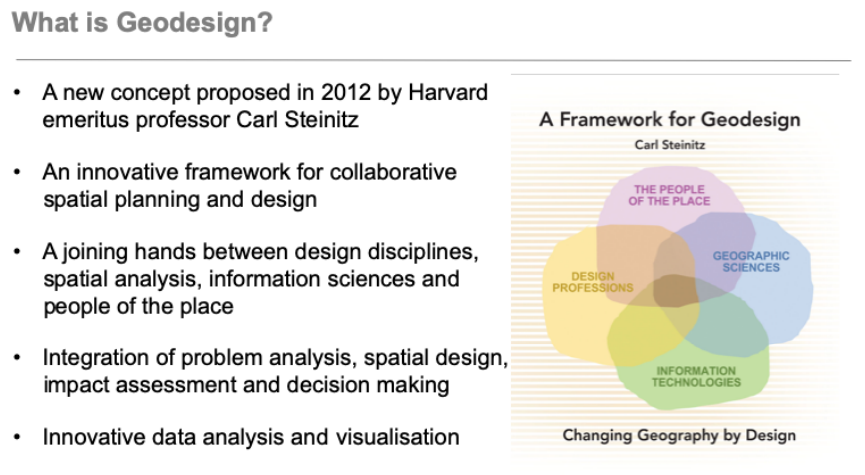
Fundamentals of Geodesign
Time: 1300-1500 hrs
The planning process becomes even more complex with the inclusion of local knowledge, and the need to gather local support. Communities do not easily let their city planners, or national politicians take decisions that affect their local community. Furthermore, communities are rarely homogenous in values or stakes, and knowledge and skill levels. Therefore, it is crucial but also challenging to include the community, or People of the place. GeoDesign has given rise to different methods and technologies to support their active involvement.
As the intellectual father of GeoDesign, we should start exploring the definitions of GeoDesign by engaging with Carl Steinitz’s 2012 book. In the book he defines Geodesign as changing Geography by design. He also introduces the four domains that should be represented in a GeoDesign team. Furthermore, he presents an integrated workflow that can support the effective collaboration between the four domains throughout the planning and design process.
We will give an overview how Geodesign has become part of the Spatial Planning.
In more detail we will explain the role of Digital Twin Infrastructures as part of the Geodesign concept.
