Training Programme

Geospatial Knowledge Infrastructure for National Development

10-12 May 2024, Rotterdam, The Netherlands
Novotel Rotterdam Schiedam

Hargalaan 2, 3118 JA Schiedam, the Netherlands, T. +31 104713322

Introduction

The future lies in adopting the geospatial way, and it is the most efficient and effective way to collect, process, integrate, and utilize information for overall global, national, and individual development. But, concentrating only on data would not suffice, and it is imperative to move up the value chain from data to knowledge through Geospatial Knowledge Infrastructure (GKI).

GKI embodies a concept that champions the evolution of a nation's geospatial ecosystem along the value chain towards knowledge, diverging from the current emphasis on data infrastructures towards the establishment of knowledge infrastructures. National geospatial infrastructures, oriented towards knowledge, serve as structures empowering countries to ascend the knowledge value chain. These infrastructures are essential for national development, and they require partnerships, knowledge sharing, and capacity building to be successful. Countries can adopt it by investing in developing a positive and collaborative approach, including government to government, government to private, government to funding agencies, academia, and research institutes.

The adoption and integration of geospatial knowledge in critical economic sectors is crucial for national development. GKI plays a significant role in this regard by integrating geospatial approaches, data, and technologies to deliver location-based knowledge, services, and solutions. By incorporating geospatial knowledge into user workflows, the potential impact on sectoral growth and development becomes evident.

The three-day training programme on ‘Geospatial knowledge infrastructure (GKI) for national development’ will address crucial questions on the growth trajectory of geospatial knowledge, the influence of new-age technology ecosystems, including AI, Big Data Analytics, Cloud Computing, Robotics and Drones on user segments, and the role and relevance of the paradigm shift from data to knowledge in national development. It will also help NGAs to improve their data management capabilities by enhancing their understanding of geospatial infrastructure, promoting data sharing and interoperability, increasing efficiency, enabling better decision-making, fostering collaboration and cooperation, and adapting to new technologies.

Learning Objectives

To gain a greater understanding of:

  • The evolving role of national geospatial agencies in digital age
  • The socio-economic impact of Geospatial Knowledge Infrastructure (GKI)
  • The geospatial knowledge value-chain and its role in sustainable development
  • The changing geospatial ecosystem and its convergence with the broader digital ecosystem
  • The growing business models for partnerships and collaborations among various stakeholders
  • The components of integrated geospatial strategies and their significance in national development

Agenda

0930 - 1000 Welcome and Introduction

Sanjay Kumar

CEO
Geospatial World
India

1000 - 1045 Lesson 1 : Relevance and importance of Geospatial Knowledge Infrastructure (GKI)

Session Highlight

  • Geospatial Knowledge Infrastructure (GKI) concepts and key elements.
  • Role and relevance of GKI in national development.
  • Evolving roles of National Geospatial Agencies (NGAs) in Digital Age.
  • Q & A

Ruban Jacob

Associate Director - GKI
Geospatial World
India

1100 - 1300 Lesson 2 : The socio-economic impact of Geospatial Knowledge Infrastructure (GKI)

Session Highlight

  • Scope and fundamentals of economic impact assessment.
  • Research Methodologies.
  • Modules of economic impact assessment for geospatial.
  • agencies.
  • Value of Economic Impact and its relationship with GKI for National Development.
  • Two case studies.
  • Q & A

Ananyaa Narain

VP - Consultancy
Geospatial World
India

1400 - 1600 Lesson 3 : Live data streams in geospatial knowledge infrastructures

Session Highlight

  • Evolution from static data to data streams to knowledge.
  • Role of real-time data in providing actionable context.
  • Technology enabling real-time observations.
  • Integration of real-time data for knowledge creation to support decision-making.
  • Case for public participation in real-time observations and decision-making.
  • Q&A

Josef Strobl

Department of geoinformatics
University of Salzburg
Austria

1630 - 1730 Lesson 4 : National Geospatial Portal

Session Highlight

  • Introduction to National Geospatial Portal (NGP) and their objectives.
  • Importance of NGPs in providing access to geospatial data and services.
  • Overview of the structure and components of NGPs.
  • Key features such as data search, visualization tools, data analysing, data download options etc.
  • Real-world examples of how NGPs have been used in different projects and applications.
  • Q&A

Alan Devenish

Solution Engineer
Esri
The Netherlands

0930 - 1130 Lesson 5 : Data Access and Interoperability

Session Highlight

  • Open data and licences
  • Metadata
  • Semantic and organisational interoperability
  • Data quality assurance and dashboards
  • Introduction to standards, data access standards, API standards
  • Integration of spatial and statistical data, meteorological data integration
  • Application of APIs
  • Q & A

Joan Maso Pau

Principal Investigator
CREAF (OGC Member)
Barcelona

1200 - 1400 Lesson 6 : Partnerships on Spatial Social Challenges

Session Highlight

  • Different types of stakeholder partnership
  • Product-centric model
  • Service-oriented model
  • Government to Government (G2G)
  • Public Private Partnership (PPP)
  • How to bring these partnerships in practice
  • Case Study of India
  • Q & A

Rosemarie Mijlhoff-Portier

Senior Consultant
Geonovum
The Netherlands

Girish Kumar

Former Surveyor General of India
Survey of India
India

1500 - 1700 Lesson 7 : Leveraging Latest Data and GeoAI Technologies for National Mapping

Session Highlight

  • Leveraging multiple imagery datasets available in the commercial industry and public sector satellites for national map updates
  • Use of technologies including AI/ML for map maintenance and updates using change detection and other techniques
  • Extending the use of national maps for diverse applications beyond traditional mapping
  • Q & A

Kumar Navulur

Founder & CEO
GeoCognition
USA

0930 - 1030 Lesson 8 : Fundamental Geospatial Data Themes

Session Highlight

  • Introduction to global fundamental geospatial data themes, as adopted by UN-GGIM
  • Theme description and importance
  • How each theme supports Sustainable development goals (SDGs)
  • Role of Fundamental Data Themes in 3D Mapping / National Digital twin
  • Q & A

Zaffar Sadiq Mohamed-Ghouse

Director, Advisory and Innovation
Woolpert Asia-Pacific
Australia

1100 - 1300 Lesson 9 : Cloud Computing

Session Highlight

  • Overview of cloud computing, including its definition, characteristics and service models
  • Cloud deployment models
  • Cloud storage and data management
  • Cloud security
  • Cloud native application development
  • Cloud-based GIS applications
  • Cloud based collaboration and sharing
  • Cloud based AI and machine learning
  • Cloud computing strategy and governance
  • Q&A

Siva Ravada

VP- Development
Oracle
USA

1400 - 1600 Lesson 10 : Geospatial Infrastructure for AEC Industry

Session Highlight

  • Introduction to Geospatial Technologies for Data Acquisition and Processing for AEC Workflow
  • Geospatial Data Integration with Building Information Modelling (BIM)
  • Geospatial Infrastructure for Planning, Design and Asset Management
  • Geospatial Applications for Construction Management
  • Case-Studies and Best Case Practices
  • Q&A

John P. Wilson

USC Professor and Founding Director
Spatial Sciences Institute, University of Southern California
USA

1630 - 1730 Lesson 11 : Legal and Policy Frameworks

Session Highlight

  • Productive partnerships between academia, government, and industry for development of national geospatial knowledge strategy
  • Strategy for implementation of standards for enhanced data acquisition, integration, and exploitation
  • Strategy for Integration of geospatial and digital ecosystems
  • Strategy for capacity development of the geospatial ecosystem
  • Q&A

Mark C. Abrams

Chief Scientific Officer
Exquisite Geolocation Systems LLC
USA

1730 - 1800 Guest Address and Certificate Distribution

Ronald Bisio

SVP
Trimble
USA

TARGET PARTICIPANTS

Topographic agencies
Hydrographic agencies
Land administration agencies
Geological agencies
Space agencies
Government geospatial data producers and providers

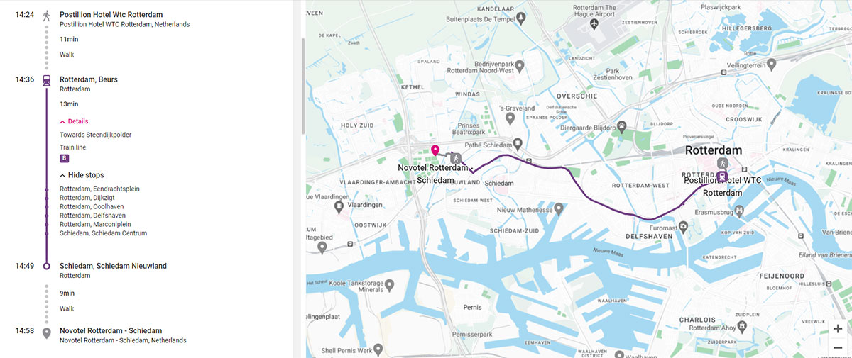
Postillion WTC Rotterdam to Novotel Schiedam can be conveniently reached in approximately 30 minutes using the tram.

Postillion
Here are the detailed directions:
  • Walk 9 minutes from Postillion WTC Convention Centre to the nearby subway tram station called "Rotterdam Beurs."
  • Board Tram Line B towards Steendijkpolder.
  • Ride the tram for 6 stations and disembark at the 7th station, which is Schiedam Nieuwland station.
  • Novotel Schiedam is just a 9-minute walk from Schiedam Nieuwland station.