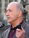
 Dr. Wubbo Johannes Ockels Dr. Wubbo Johannes Ockels
Professor of Aerospace for
Sustainable Engineering and
Technology Delft University,
The Netherlands
Bio
Wubbo Johannes Ockels is a Dutch physicist and a former astronaut of the
European Space Agency. In 1985 he participated in a flight on a space
shuttle (STS-61-A), making him the first Dutch citizen in space. In 1978, he
was selected by the European Space Agency (ESA) as one of three European
payload specialists to train for the Spacelab 1 mission. In May 1980, under
agreement between ESA and NASA, Ockels and Swiss astronaut Claude
Nicollier were selected to begin the basic astronaut training for mission
specialist together with the NASA astronaut candidates at NASA's Johnson
Space Center, Houston, Texas. In 1992, Ockels was appointed part-time
professor Aerospace Engineering at the Delft University of Technology, and
promoted to full-time professor in September 2003. In this function, he
has overseen the Nuna projects. He has also proposed the development of
a Superbus, a new method of high speed (250 km/hour) public transportation
by road. The public transportation company Connexxion is the first company
to invest in the development of this Superbus.
|
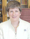 Dr. Vanessa Lawrence CB Dr. Vanessa Lawrence CB
Director General and Chief Executive
Ordnance Survey
UK
Bio
Vanessa Lawrence is the Director General and Chief Executive of
Ordnance Survey, Great Britain’s national mapping agency. She is
the first woman to head Great Britain's national mapping agency
and when appointed, was one of the youngest Director Generals
in Ordnance Survey’s 220-year history. She is a world-renowned
expert in how GIS can improve decision making at all levels of
government and business. Vanessa is the adviser to the British
Government on short and medium strategies for mapping,
surveying and geographic information. In addition to her work at
Ordnance Survey, Vanessa is a former Chair of the United Kingdom
ACE Association, the organisation representing Chief
Executives of Government Agencies, Trading Funds and Non-
Departmental Public Bodies on behalf of the Cabinet Secretary.
|
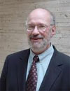 David Schell David Schell
Emeritus Chairman
Open Geospatial Consortium
USA
Bio
David Schell, Chairman Emeritus of the OGC Board is also
currently serving as Chief Strategist for the corporation, focusing
on strategic initiatives and relationships designed to serve the
evolving needs of the organization and its growing membership
community and stakeholders. Schell served as both Chairman
and CEO of OGC from its founding in 1994 until 2008. As Executive
Chairman from 2008 to 2012, David was principally concerned
with overseeing board operations and organizing the consortium's
strategic planning process. Prior to developing the "Open GIS"
process, Schell worked in the computer industry as a system
programmer, marketing support engineer and technical writing
manager for IBM, Honeywell Information Systems, and Data
General Corp., respectively.
|
 Alain De Taeye Alain De Taeye
Board Member
TomTom BV.
The Netherlands
Bio
Alain De Taeye, born in Belgium, graduated as engineer-architect
from the University of Gent. After having done research work in
the field of Operations Research at the Business School of the
Gent University, he founded Informatics & Management Consultants
(I&M) where, next to IT consultancy, he continued his work
on digital map databases and routing. In 1989 I&M was integrated
into the Dutch Tele Atlas group and as of 1990 Alain headed the
Tele Atlas group. During this period, he successfully introduced
Tele Atlas on both the Frankfurt and the Amsterdam Stock
Exchanges. In 2008 Tele Atlas was acquired by TomTom and Alain
joined the Management Board of the TomTom group.
Abstract
Geospatial: The Past and the Future by TomTom
2012 marks the 500 year anniversary of the birthday of 16th century Flemish cartographer Gerardus Mercator. The invention of paper maps based on years and years of survey became a revolution in which the paper maps were used for in-car navigation and were eventually succeeded by advances in technology that enable a range of applications for the map. The debut of the digital map 30 years ago literally brought the map to life as it became a more dynamic asset. With the invention of the digital map came demands for additional content and more up-to date maps that reflect the reality of the world around us. With significant expertise in developing a digital map database of the world, TomTom uses a hybrid approach to map-making that includes the combination of authoritative sources, such as field collection, government data or satellite imagery, with community input, enables TomTom partners to refresh location aware applications and GIS solutions with the most up-to-date map and enhanced attribution available. Alain will show the development of innovative tools that enable freshness in the map, reflecting reality on the roads. This new and fresh data is not only essential for new generations of navigation solutions but also for business intelligence, transportation and logistics, government planning, and many more markets and use cases.
|
 Steven Hagan Steven Hagan
Vice President
Oracle Inc.
USA
Bio
Steven Hagan has been responsible since 1994 for Oracle's Nashua,
New Hampshire development facility, where he has responsibility
for Oracle's development and associated strategic relationships
in the areas of Oracle Spatial, the Semantic Web, Medical Imaging
& related services, and "Data Movement/High Availability". Steven
is a 40-year veteran of the software industry. Before joining Oracle,
he spent seven years at Digital Equipment Corporation as the
senior engineering manager for database technologies. The particular
strategic contribution of Steven Hagan's organization is its
extensive network of strategic relationships with nearly all of the
key geospatial software and data suppliers; its special concentration
on very large databases; and, its focus on addressing "Spatial
Intelligence" and the mainstreaming of Location into Business
Intelligence and numerous related applications.
|
 Ben Semmes Ben Semmes
COO
PB Software
USA
Bio
Ben Semmes brings twenty years of software industry
experience to his role as Group Operating Officer. In this capacity,
Semmes leads Pitney Bowes Software’s global efforts to align all
resources (people, process and systems) to most effectively drive
the company’s global growth strategy. Semmes has established
standard business practices and collaboration initiatives across
North America, Europe and Asia Pacific regions, resulting in
increased customer satisfaction, organizational efficiency and
profitability. Semmes’ previous role at Pitney Bowes Software was
Senior Vice President, Global Services, where he led predictive
analytics, consulting, support, education and online-services
worldwide.
Abstract
Changing World and Changing Priorities: Enabling a Geospatial World
We live in a changing world, rich with spatially-relevant phenomenon, data and activities. This new spatially rich world created new challenges, realties, and opportunities for both business professionals and policy makers. The spatial nature of many of today’s challenges and the global economic downturn warrant new ways of thinking and applying geospatial and non-geospatial technologies to solve urban and environmental problems. This also warrants a paradigm shift in the way we conduct business to leverage location intelligence to create an infrastructure for everyday collaboration and communication in all of its forms and various stakeholders. Spatial information provides context, enables relevance and enhances understanding of critical issues such as smart development and customer experience to allow sustainable growth. This understanding can be augmented with non-geospatial information and the new ways of interaction, such as social media. The conversion of both geospatial and non-geospatial technologies makes location intelligence enabled thinking and application to yield desired outcomes for customers, communities and other stakeholders possible.
|