|
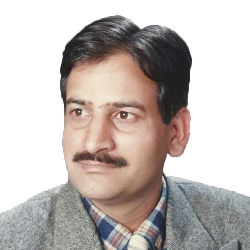
R. S Rathi
Vice President
Defense & Security
Rolta India Ltd.
BiographyRS Rathi is working as Vice President (Defense & Security), Rolta India Ltd., Mumbai. He has specialization in the area of Remote Sensing, Digital Cartography and Geographical Information System technologies. He has more than 25 years of experience in utilization of geospatial technologies for development and implementation of end-to-end Defense & Security solutions for customers.
Prior to join Rolta, RS Rathi had severed in National Forest Data Management Centre (NFDMC), Forest Survey of India, Ministry of Environment & Forest and Urban & Regional Information System (URIS), Town & Country Planning Organization, Ministry of Urban Development , Government of India (GoI). During his tenure with GoI, he worked on various key projects funded by Food and Agriculture Organization (FAO), United Nation Development Program (UNDP) and World Bank.
Played key role in implementation of Rolta’s Digital Mapping and Cartographic systems for production of Digital topographic map and charts database/ products in National mapping agencies like Survey of India, Military Survey, and National Hydrographic Office. Apart from above, his contribution is notable for development and deployment of Command and Control (C2) Intelligence Surveillance and Reconnaissance (ISR) solution at Strategic, Operational and Tactical levels for Indian defense forces.Abstract Next Generation C2ISR solutions for Situational awarenessIn the past one decade, the nature of data has changed dramatically, with an explosion in the volume, variety and velocity of geospatial (high resolution imageries, large scale topographic maps, UAV/Drone imagery/motion video, Terrain & tactical overlays) data.
Old computerized mapping systems are simply unable to cope with the Big data needed to give the end user a complete perception of his environment. Some operators are forced to look at multiple screens simultaneously before integrating the information in their heads. This is simply not a reliable model for efficient decision-making.
High performance, real-time visualization of information is a prerequisite for successful Geospatial Situational Awareness applications. High performance visualization components track up to half a million simultaneous moving objects in real-time, allowing users to get the job done, quickly and safely.
Next Generation solutions are deployable on Servers, desktops, laptops and smart mobile devices / platforms running on heterogeneous Operating System environments to meet the operational need of defense forces.
High-end software solutions for building state of the art situational awareness systems provide best-of-class visualization, data fusion, and advanced data processing and analysis software, to help users turn superior Situational Awareness to their strategic, operational and tactical level competitive advantage.
|
