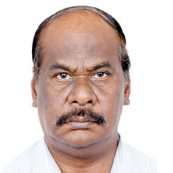
Speakers Bio & Abstract

|
DR A JEYARAM
Chief Executive Officer SECON India BiographyDr. A. Jeyaram has completed his Master of Technology from Roorkee University (Now IIT, Roorkee) in the field of Geosciences and obtained Ph.D in water resources from Nagpur University. He joined Indian Space Research Organization in the year 1986 as scientist and specialized in the areas of remote sensing and GIS. He was involved in the application Validation program of ISRO using IRS series of satellite data, Resourcesat satellite data, OCM data, RISAT satellite data utilization for geosciences, water resources, ground water, land use / land cover, forestry, mineral exploration, coastal and environmental applications. He has worked in various capacities and contributed in design and methodology development of ISROs National Natural Resource Management System programs. In 2001, he became head of Regional Remote Sensing Service Centre, ISRO at IIT Kharagpur. During the period, he has carried out and supervised more than 200 user projects and software development in the areas of remote sensing and GIS. Involved in the ISROs national level program like Integrated Mission for sustainable development (IMSD), Natural Resource Information System (NRIS), Crop Acreage & Production estimation, Land use/land cover mapping, land degradation mapping, Rajiv Gandhi National Drinking Water Mission (RGDWM) etc
As General Manager & Project Director, Regional Remote Sensing Centre, ISRO, Kolkata from 2011 he contributed to the national program of ISRO like Space Based Information Support for De-centralized Planning (SIS-DP), National level Tea area development & Management (Tea GIS & MIS) etc. He was also coordinating as a member of Governing Body for all remote sensing & GIS based developmental program of West Bengal, Orissa, Jharkhand, Bihar, Sikkim and Assam states for which Chief Secretary of the respective state is the Chairman.
He is recipient of three ISRO Team Awards
From December 2013 onwards, He was working as Advisor, RS & GIS in SECON Private Limited effectively contributing to the projects of Photogrammetry, Lidar, RS and GIS departments
Appointed as Chief Executive Officer of SECON Private Limited from 1st Nov 2014 onwards.
Has travelled to many countries including Syria, Thailand, South Korea, Austria etc in various capacities as Government representative and also representative of SECON Private Limited.
Has credentials of more than 40 scientific paper publications in international / national journals and conferences of international reputation.
Abstract Conclusive Titling and GIS based Land Records Management SolutionsIn 2008, the Government of India has decided to move from the current Presumptive Property Titling system to the system of Conclusive Property Titling as a major step towards modernization of Land records in the country under the under “Digital India – Land Records Modernization Program”. As per the Registration Act of 1908, registration of deeds/documents of land records do not confer a conclusive title to the property owner. The current Presumptive property titling system indicate a right over a property arising out of mere occupation / possession without apparent right until the possession is obstructed. |